Weather Center brings you the Severe Weather Forecast this week! There is now a chance for severe weather for DFW this week! On Wednesday, there is a new line of storms that will advance with a Cold Front and potentially cause a couple small tornadoes, large hail, and strong winds. Additionally, the storms that occurred on Sunday (4/19/20) did not cause nearly as many tornadoes or lives. View the storm reports and details here.
(https://www.spc.noaa.gov/climo/reports/yesterday.html)
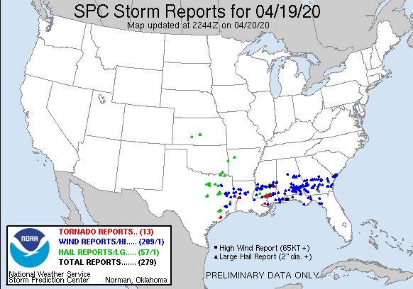
Only 13 Tornadoes with 209 reports of strong winds and 57 of hail. To Compare, check out the Easter Storm reports we had on 4/12/20:
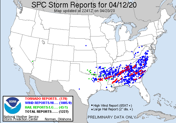
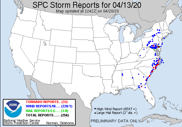
232 Tornado Reports, 1225 strong Wind Reports, and 46 Hail Reports! This Outbreak went down in the history books for sure. In fact, it did….
BACK TO THE SEVERE WEATHER POTENTIAL:
Severe Weather Forecast
The chance of severe weather and the variables we still don’t quite have leaves this open for many things to change. BUT, never the less, we must be cautious and heed warnings that meteorologists give us. Here is the SPC Discussion on the storms Wednesday:
Discussion:
ACUS03 KWNS 200735
SWODY3
SPC AC 200734

Day 3 Convective Outlook
NWS Storm Prediction Center Norman OK
0234 AM CDT Mon Apr 20 2020

Valid 221200Z - 231200Z

...THERE IS A SLIGHT RISK OF SEVERE THUNDERSTORMS FROM PARTS OF THE
SOUTHERN PLAINS INTO THE LOWER MISSISSIPPI VALLEY...

...SUMMARY...
Severe storms are possible Wednesday from the southern Plains into
the lower Mississippi Valley.

...Discussion...
A positive-tilt shortwave trough will move from the southern Plains
eastward across the Gulf Coast states, with a broad area of
west/southwest 50-60 kt midlevel winds. At the surface, a weak area
of low pressure will move from OK during the day into AR, with a
front surging east across northern TX and the ArkLaTex. A dryline
will punch east across TX, except for Deep South TX where it will
become stationary.

East of the dryline, southerly winds will result in moisture
recovery over much of eastern TX during the day with mid to upper
60s F dewpoints common, then across LA and southern MS overnight.
The rapid advection of moisture into a relatively cool air mass over
the Southeast will result in widespread clouds, which will inhibit
heating except near the dryline (near I-35 in TX and OK).

The greatest threat of severe storms, including damaging hail, will
be near this dryline where storms will have access to stronger
heating. Despite a pronounced veer/back signal in the low-level wind
profile, strong deep-layer shear will support sustained cells,
perhaps a few supercells.

Numerous storms will persist overnight as they move into the lower
MS Valley, but the boundary layer, although moistening, will be
relatively cool. Thus, despite large SRH, it is unclear how much of
a tornado threat there will be. More likely, an MCS will produce
areas of wind damage.

..Jewell.. 04/20/2020

$$
Monday SPC Discussion
ACUS01 KWNS 201957
SWODY1
SPC AC 201955

Day 1 Convective Outlook
NWS Storm Prediction Center Norman OK
0255 PM CDT Mon Apr 20 2020

Valid 202000Z - 211200Z

...THERE IS A SLIGHT RISK OF SEVERE THUNDERSTORMS LATE THIS
AFTERNOON AND EVE ACROSS PARTS OF SOUTHERN MISSOURI...

...SUMMARY...
A few strong to severe thunderstorms are possible late this
afternoon into tonight across parts of the central Florida
Peninsula, the Ozark Plateau, and southern Plains.

...20Z Outlook Update...
Some changes have been made, mostly to account for ongoing trends in
observational data.  Aside from the Florida Peninsula and portions
of the Upper Midwest, these are mostly minor.

...Florida Peninsula...
Primary mid/upper support for convective development now appears
well offshore, in the Atlantic, and deep-layer mean wind fields,
while still fairly strong, are in the process of gradually
weakening.  Flow around 850 mb has a pronounced westerly component,
and boundary-layer mixing across interior southern and eastern
portions of the peninsula has resulted in lowering surface dew
points and more modest CAPE ahead of the lingering pre-frontal line
of storms.  Coupled with generally weak low-level convergence,
convective potential appears on the wane, with severe weather
potential becoming increasingly isolated to negligible through late
afternoon.

...Upper Midwest...
Convective development is underway near/just ahead of a vigorous
digging mid/upper short wave trough, as strong mid-level cooling
(coupled with continuing insolation) contributes to steepening
lower/mid tropospheric lapse rates.  The axis of strongest
pre-frontal surface heating and boundary-layer mixing now extends
across southwestern Minnesota through portions of central Wisconsin,
where the most prominent convective band appears to be evolving
(including sustained embedded lightning near/west through northeast
of LaCrosse WI).  However, surface dew points in the mid 20's to
near 30F along this axis are only allowing for very weak CAPE.
While some downward mixing of 40-50 kt flow in the 850-700 mb layer
appears possible as the convection spreads southeastward through
early evening, the potential for more than sporadic localized strong
surface gusts appears low, with peak gusts probably remaining mostly
below severe limits.

..Kerr.. 04/20/2020

.PREV DISCUSSION... /ISSUED 1120 AM CDT Mon Apr 20 2020/

...FL Peninsula...
A broken squall line continues to progress southward across the
central FL peninusla.  Occasional supercell and bowing structures
continue to be noted along the line, posing a risk of damaging wind
gusts and isolated brief tornadoes.  The overall severe threat
should continue to diminish through the day as storms move into a
progressively weaker sheared environment.

...MO/OK vicinity...
Water vapor imagery shows a fast-moving shortwave trough over KS
embedded within northwest flow aloft.  Lift in vicinity of this
feature is expected to result in scattered afternoon thunderstorm
development across parts of southern MO - and along the flanking
line of ascent that extends westward along the KS/OK border.
Forecast soundings suggest MLCAPE values over 1000 J/kg, cold
temperatures aloft leading to steep midlevel lapse rates, and strong
deep layer shear.  This will promote a risk of large hail in the
most intense storms this afternoon.  The highest potential appears
to be over southern MO, where a small SLGT risk has been added.
Gusty winds are also expected in the more established storms.

...Upper MS Valley...
Another fast-moving shortwave trough is digging southeastward across
MN.  This system will also lead to scattered showers and a few
thunderstorms over parts of MN/IA/WI during the afternoon hours.
Forecast soundings in this area have minimal CAPE, which should
substantially limit updraft strength.  However, strong westerly flow
coupled with a deep and well-mixed boundary layer will promote gusty
winds in the convection that forms.

...Northeast TX overnight...
12z CAM guidance is in very good agreement that a narrow corridor of
thunderstorms will form after midnight tonight over parts of
northeast TX.  Forecast soundings suggest these storms will likely
be elevated, but sufficient lapse rates and deep-layer shear could
result in some hail.

$$
Forecast data is produced manually by expert meteorologists at the NWS Storm Prediction Center. See their site for the most up-to-date official forecasts.
So, to decode that message for y’all, we have unknowns, we have variables that could change, but there is a storm system that will move on in on WEDNESDAY with a low pressure area and a cold front that could produce severe weather. SPC has issued a Slight Risk also for this area:
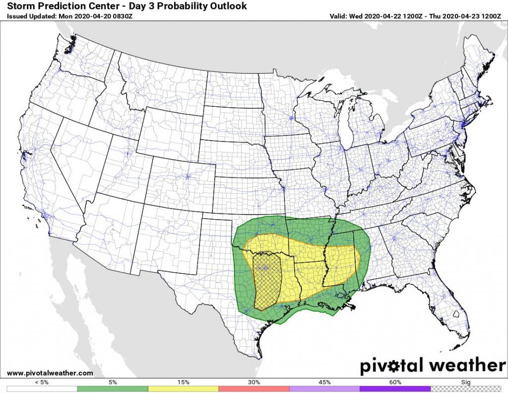
SPC has already shown that they may INCREASE the risk to a Enhanced over where the Sig zone is. This is due to the instability that is seen in the atmosphere at this time. SO, stay safe, know your severe weather forecast, stay weather aware, and look for more of these updates on https://www.weathercentertx.com !