Hurricane Ian is expected to make landfall as at least a CAT 3 hurricane around Tampa Bay, Florida. See the latest info from Hurricane Tracker by Texas Weather Center and take a look at NHC’s discussion on the hurricane.
Key Messages by NHC:
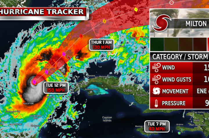
1. Life-threatening storm surge, hurricane-force winds, flash floods and possible mudslides are expected in portions of western Cuba today. Devastating wind damage is expected where the core of Ian moves across western Cuba this morning.
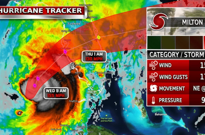
2. There is a danger of life-threatening storm surge along much of the Florida west coast where a storm surge warning has been issued, with the highest risk from Fort Myers to the Tampa Bay region. Residents in these areas should listen to advice given by local officials.
3. Hurricane-force winds are expected in the hurricane warning area in west-central Florida beginning Wednesday morning with tropical storm conditions expected by late today.
4. Heavy rainfall will spread across western Cuba through Tuesday. This will likely produce instances of flash flooding and possible mudslides in areas of higher terrain over western Cuba.
5. Heavy rainfall will increase across the Florida Keys and South Florida Tuesday, spreading into central to northern Florida Wednesday and Thursday, and the Southeast by Friday and Saturday, likely causing flash, urban, and small stream flooding. Considerable flooding is expected across Central Florida into southern Georgia and coastal South Carolina, with significant, prolonged river flooding expected across central to northern Florida.
Become a TWC Member today for FREE!
Support Texas Weather Center
Join the TWC Membership through Patreon to show your support and keep TWC high quality and FREE!
Texas Weather Center Supporters
🥉Kathryn
🥇David Bass
🥉cslewis1234
🥉Robert Fasulo
🥈Carol
Join TWC’s Facebook Group to interact with a community, see the latest updates from TWC, and share your weather photos!