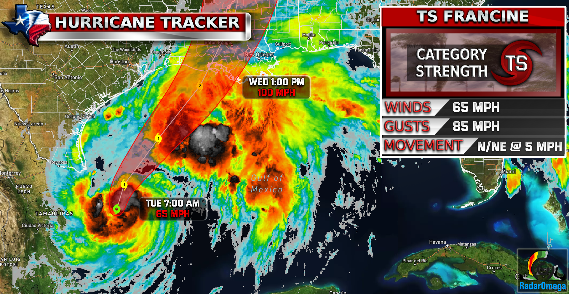
Tropical Storm Francine is expected to undergo rapid intensification over the next 24 hours. It is expected to become a hurricane in the next few hours today and the maximum expected strength before landfall is forecasted to be a strong CAT 2 at 105 MPH winds and 125 MPH gusts. Massive storm surge, some tornadoes, and high winds seem to be the main concerns with this storm. The rainfall threat is not as extreme as Beryl was, but up to 10 inches of rainfall is still possible in some areas. Grand Isle Mayor has issued evacuation orders due to Tropical Storm Francine in Louisiana. There is a mandatory evacuation order for all campers, RVs, cargo, and boat trailers and a voluntary evacuation order for all other residents. Stay tuned to your local news if you live in the Louisiana-Mississippi coastline area!
1. There is a danger of life-threatening storm surge for portions of the Upper Texas, Louisiana, and Mississippi coastlines where a Storm Surge Warning is in effect. Residents in the warning area should follow advice, including evacuation orders, given by local officials.
2. Damaging and life-threatening hurricane-force winds are expected in portions of southern Louisiana Wednesday, where a Hurricane Warning is in effect. Preparations to protect life and property should be complete by tonight, since tropical storm conditions are expected to begin within this area early Wednesday.
3. Francine is expected to bring heavy rainfall and the risk of considerable flash and urban flooding for far northeast Mexico into the far southern coast of Texas today and across much of Louisiana and Mississippi through Thursday. Flash and urban flooding is probable across the Mid-South Wednesday night into Friday morning.

| Satellite Imagery
See the latest Satellite Imagery of the southern plains, the US, and the whole disk! See various types of imagery like infrared, water vapor, visible, and more!
Landfall
5:00 PM Wednesday
Current Intensity
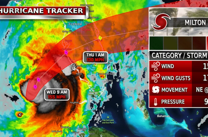
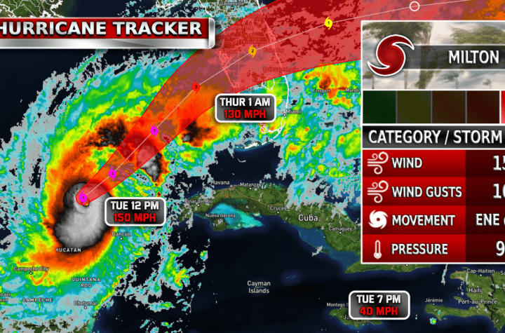
TS / 65 MPH
Max Expected Intensity
CAT 2 / 105 MPH
| Rainfall Totals

| Peak Storm Surge

| Flash Flood Outlook

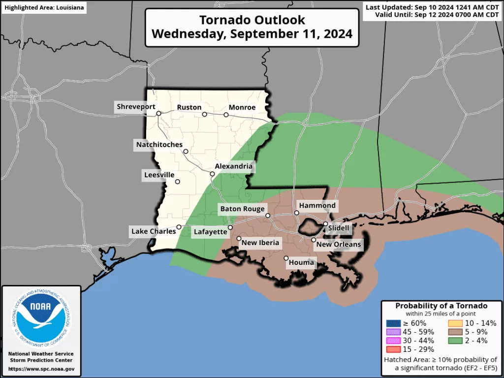
| Tornado Outlook
| TWC Info Maps
")

| TS Force Wind Probabilities

| Hurricane Wind Probabilities

| Tracking Map

| Spaghetti Models

| Warnings / Surface Winds

| Latest IR Satellite Imagery

Become a TWC Member today for FREE!
Support Texas Weather Center
Join the TWC Membership through Patreon to show your support and keep TWC high quality and FREE!
Texas Weather Center Supporters
🥉Kathryn
🥇David Bass
🥉cslewis1234
🥉Robert Fasulo
🥈Carol
Join TWC’s Facebook Group to interact with a community, see the latest updates from TWC, and share your weather photos!