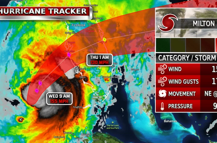
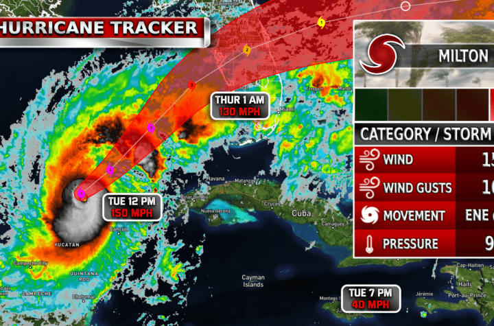
Weather models indicate a hurricane potentially in the gulf in the next week’s time. NHC has a 40% orange zone over the Yutacan peninsula area indicating possible development in the next week. It is a complicated setup due to current conditions, so we can’t trust these computer models completely yet.
| Simulated Weather Models
September 27th – 29th


Until there is an actual area of low pressure to track its speed and position, it is still pretty much a guessing game on how this storm will all play out. Currently, the GFS weather model is indicating a fairly strong hurricane forming and entering the gulf by September 27-29 with low-pressure values down to the low 960 mbs. These conditions are improved from the previous models that indicated 930 mbs (a worse hurricane). Assuming the models are fairly accurate, this future potential hurricane could be posing a threat for Louisiana and as far East as the entire coast of Florida. Remember, things WILL change and this event is still 7+ days out so weather predictions now aren’t perfect. Stay weather aware
| Satellite Imagery
See the latest Satellite Imagery of the southern plains, the US, and the whole disk! See various types of imagery like infrared, water vapor, visible, and more!
| 7-Day Tropical Weather Outlook

| Latest IR Satellite Imagery

Become a TWC Member today for FREE!
Support Texas Weather Center
Join the TWC Membership through Patreon to show your support and keep TWC high quality and FREE!
Texas Weather Center Supporters
🥉Kathryn
🥇David Bass
🥉cslewis1234
🥉Robert Fasulo
🥈Carol
Join TWC’s Facebook Group to interact with a community, see the latest updates from TWC, and share your weather photos!