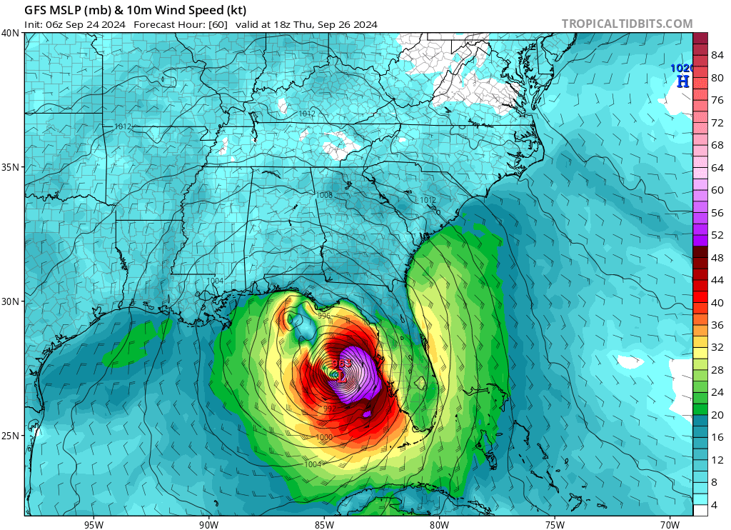
Potential Tropical Cyclone Nine (Tropical Storm by lunchtime today), is expected to intensify into Hurricane Helene, posing a significant threat to Florida and the southeastern U.S. Helene is forecasted to bring storm surge up to 10-15 feet in some areas along parts of Florida’s Gulf Coast, particularly in low-lying areas from the Big Bend region down to Tampa Bay. This storm surge could lead to life-threatening coastal flooding, especially where winds push water onshore. Wind gusts are expected to reach speeds past 100 mph, it is still unknown how strong the winds will be from soon-to-be Helene
Heavy rainfall is anticipated, with estimates of 4 to 8 inches across parts of northern and central Florida, and isolated totals of up to 10 inches in some regions. This could result in flash flooding, especially in low-lying areas. The storm’s impacts could extend beyond Florida, affecting parts of Georgia and the Carolinas as it moves inland.
Mandatory evacuation orders are expected, particularly in coastal counties like Taylor, which is preparing for significant storm impacts. Franklin County has already issued a mandatory evacuation of all residents, and many more counties will most likely follow. Residents in evacuation zones have been advised to prepare now and heed local warnings. Cities like Tallahassee are also making preparations, such as distributing sandbags to mitigate flooding.
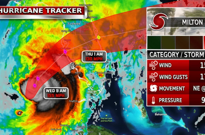
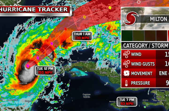
Helene’s outer bands will begin impacting southern Florida on Wednesday, with tropical storm conditions starting late that evening. The main event will occur on Thursday as the storm makes landfall, likely between the afternoon and evening. The strength of the hurricane will all depend on how fast it intensifies and how fast it is moving once it fully enters the gulf later today into tomorrow.
Residents in the storm’s path should complete preparations now! Monitor this storm hourly to stay on top of updates and notices. This storm is expected to be dangerous and life-threatening and should not be taken lightly. Please share this information with all your Florida friends and family in the path.
KEY MESSAGES FROM NHC:
1. The disturbance is forecast to intensify and be near hurricane strength when it reaches the far northwestern Caribbean Sea early Wednesday. Tropical storm conditions are expected over portions of western Cuba and the northeastern coast of the Yucatan Peninsula with hurricane conditions possible.
2. The system is expected to intensify into a major hurricane before it approaches the northeastern Gulf Coast on Thursday, and the potential for life-threatening storm surge and damaging hurricane-force winds along the coast of the Florida Panhandle and the Florida West Gulf Coast is increasing. Hurricane and Storm Surge Watches have been issued, and residents should ensure they have their hurricane plan in place and also follow advice given by local officials.

| Simulated Weather Models


| Simulated Intensity Guidance

| Satellite Imagery
See the latest Satellite Imagery of the southern plains, the US, and the whole disk! See various types of imagery like infrared, water vapor, visible, and more!
| 7-Day Tropical Weather Outlook

Landfall
Afternoon Thursday
Current Intensity
Invest Nine
Max Expected Intensity
CAT 3+ ?
| Rainfall Totals

| Peak Storm Surge

| Flash Flood Outlook

| TS Force Wind Probabilities

| Hurricane Wind Probabilities

| Tracking Map

| Spaghetti Models

| Warnings / Surface Winds

| Latest IR Satellite Imagery

Become a TWC Member today for FREE!
Support Texas Weather Center
Join the TWC Membership through Patreon to show your support and keep TWC high quality and FREE!
Texas Weather Center Supporters
🥉Kathryn
🥇David Bass
🥉cslewis1234
🥉Robert Fasulo
🥈Carol
Join TWC’s Facebook Group to interact with a community, see the latest updates from TWC, and share your weather photos!