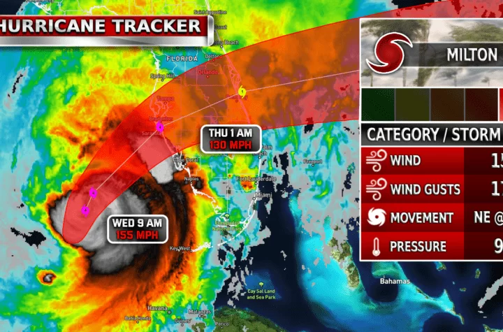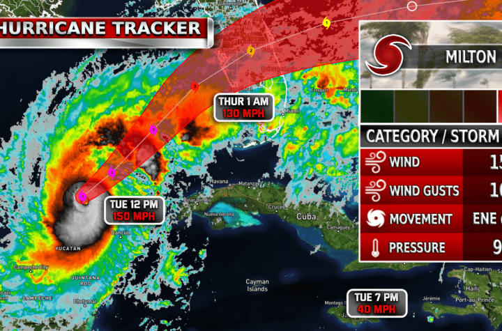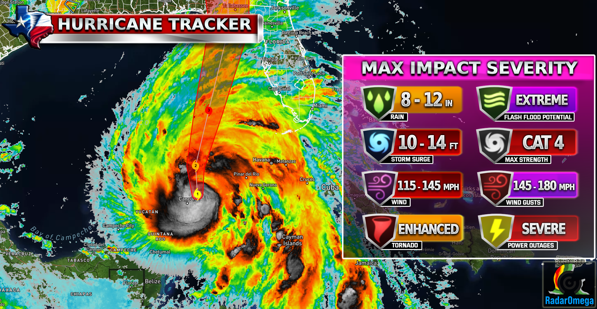
Hurricane Helene is currently intensifying in the Gulf of Mexico and is projected to become a major hurricane before making landfall along the Florida Gulf Coast on Thursday around late afternoon. The storm is expected to reach a strong CAT 3, with life-threatening impacts, including storm surge, heavy rainfall, and strong winds. Many models also indicate a strong CAT 4 is possible if the storm moves slow enough and intensifies fast enough.
Helene’s large size poses a significant storm surge threat along the entire west coast of Florida, with water levels potentially reaching 10-15 feet above normal in some areas, particularly from the Ochlockonee River to Chassahowitzka. Evacuations have been ordered in vulnerable regions
Heavy rainfall is forecast across the southeastern U.S., with the potential for 4-8 inches of rain and isolated totals of up to 12 inches, leading to flash flooding in both urban and rural areas. Power outages and tree damage are also expected as the storm moves inland.
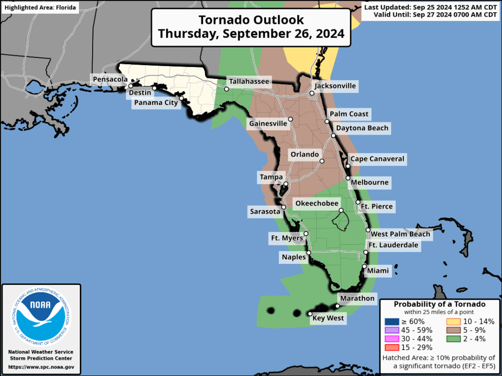
Hurricane Helene poses a significant tornado threat as well, particularly as it makes landfall and moves inland. Tornadoes are common in the outer rainbands of hurricanes due to the wind shear and unstable air in those regions. The greatest tornado threat will be along Florida’s Gulf Coast in areas north and east of the storm’s center. As Helene pushes inland, the tornado risk will extend into southern Georgia. The tornado threat may persist through Friday as the storm continues inland.
Residents in affected areas should complete preparations by today! weather conditions will start degrading by late tonight and conditions will become dangerous and life-threatening by tomorrow as landfall grows closer.

| Simulated Weather Models


| Simulated Intensity Guidance

| Satellite Imagery
See the latest Satellite Imagery of the southern plains, the US, and the whole disk! See various types of imagery like infrared, water vapor, visible, and more!
| 7-Day Tropical Weather Outlook

Landfall
7:00 PM Thursday
Current Intensity
CAT 1 / 80 MPH
Max Expected Intensity
CAT 4 / 130 MPH
| Rainfall Totals

| Peak Storm Surge

| Flash Flood Outlook

| Tornado Outlook
| TWC Info Maps

| TS Force Wind Probabilities

| Hurricane Wind Probabilities

| Tracking Map

| Warnings / Surface Winds

| Latest IR Satellite Imagery

Become a TWC Member today for FREE!
Support Texas Weather Center
Join the TWC Membership through Patreon to show your support and keep TWC high quality and FREE!
Texas Weather Center Supporters
🥉Kathryn
🥇David Bass
🥉cslewis1234
🥉Robert Fasulo
🥈Carol
Join TWC’s Facebook Group to interact with a community, see the latest updates from TWC, and share your weather photos!