NHC Latest Updates:
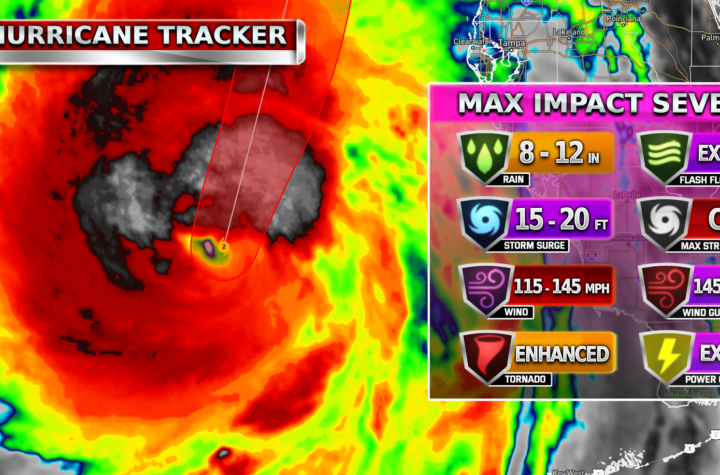
A large area of destructive storm surge, with highest inundations of 10 ft or greater, is expected along a portion of the west-central coast of the Florida Peninsula. If you are in the Storm Surge Warning area, this is an extremely life-threatening situation, and you should evacuate as soon as possible if ordered by local officials.
Devastating hurricane-force winds are expected along portions of the west coast of Florida, where a Hurricane Warning is in effect. Milton is forecast to remain a hurricane while it crosses the Florida Peninsula and life-threatening hurricane-force winds, especially in gusts, are expected to spread inland across the peninsula. Preparations to protect life and property, including being ready for long-duration power outages, should be rushed to completion.
Heavy rainfall across the Florida Peninsula through Thursday brings the risk of catastrophic and life-threatening flash and urban flooding along with moderate to major river flooding, especially in areas where coastal and inland flooding combine to increase the overall flood threat.
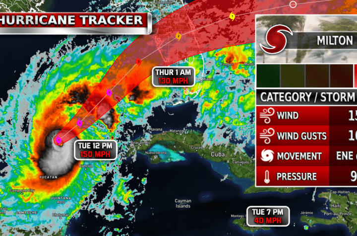
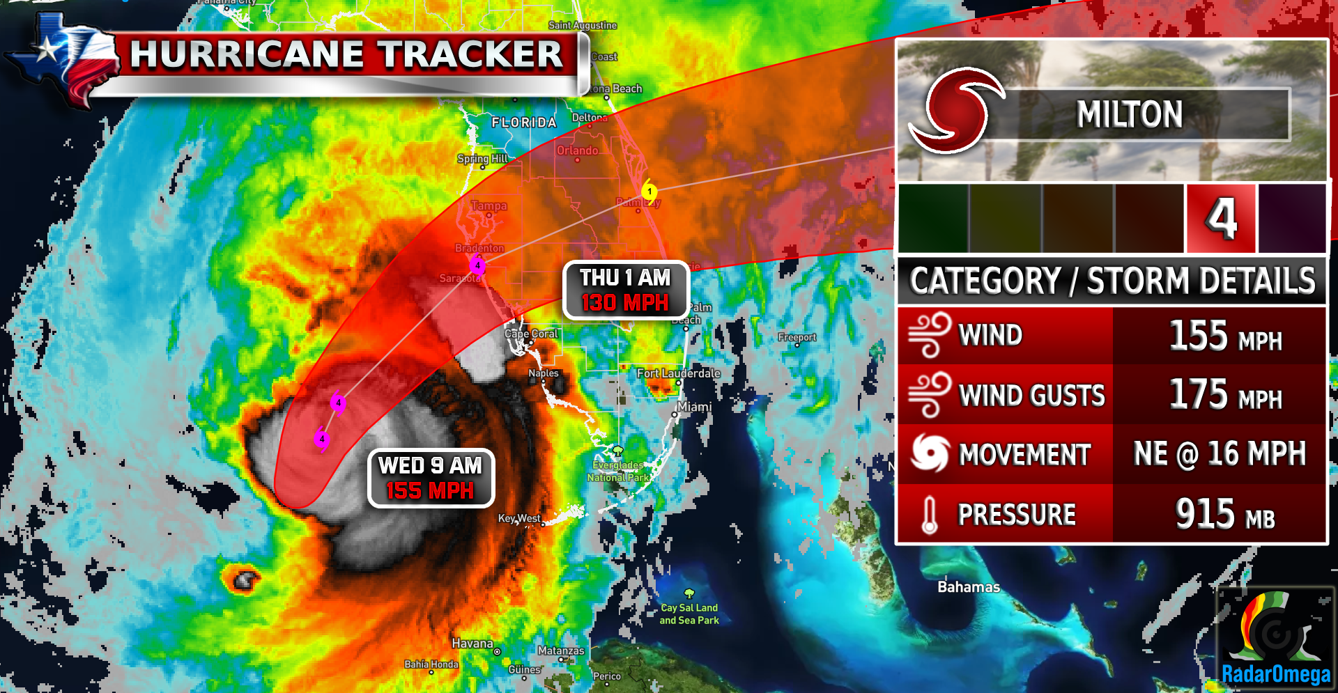
As of today, Hurricane Milton remains a Category 4 storm with sustained winds of 155 mph, just below CAT 5 status. The hurricane is located in the eastern Gulf of Mexico and is moving toward Florida’s west-central coast. It’s expected to make landfall late tonight or early tomorrow, bringing life-threatening storm surges, heavy rainfall, and hurricane-force winds across a large area. Milton is expected to encounter some wind shear later today which will hopefully weaken the storm further before landfall. Follow TWC live on Facebook as it does real-time updates tonight! Or follow on TWC’s Live Updates page. Stay weather aware

| Simulated Intensity Guidance

| Satellite Imagery
See the latest Satellite Imagery of the southern plains, the US, and the whole disk! See various types of imagery like infrared, water vapor, visible, and more!
| 7-Day Tropical Weather Outlook

Landfall
1 AM Thursday
Current Intensity
CAT 4 / 155 MPH
Landfall Intensity
CAT 4 / 130 MPH
| Rainfall Totals

| Peak Storm Surge

| Flash Flood Outlook

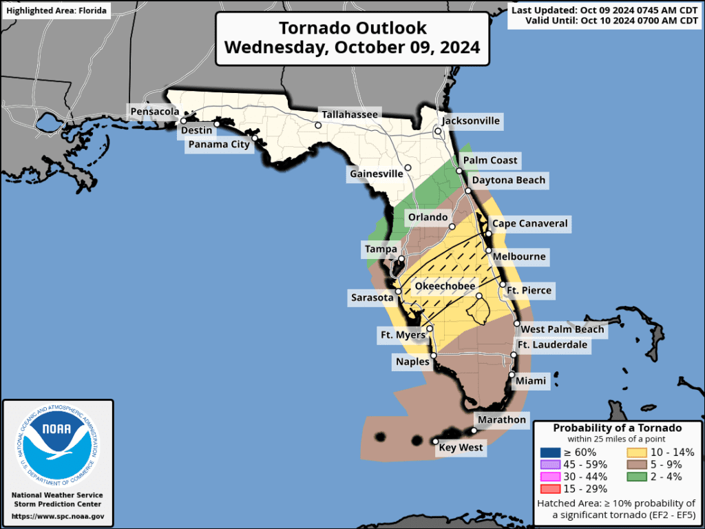
| Tornado Outlook
| TWC Info Maps

| TS Force Wind Probabilities

| Hurricane Wind Probabilities

| Tracking Map

| Warnings / Surface Winds

| Latest IR Satellite Imagery

Become a TWC Member today for FREE!
Support Texas Weather Center
Join the TWC Membership through Patreon to show your support and keep TWC high quality and FREE!
Texas Weather Center Supporters
🥉Kathryn
🥇David Bass
🥉cslewis1234
🥉Robert Fasulo
🥈Carol
Join TWC’s Facebook Group to interact with a community, see the latest updates from TWC, and share your weather photos!