Arctic Blast Potential January 7-11th
Update #2 folks! The forecast has changed a little bit since the last TWC post. Some slight temperature modifications and a BIG introduction to potential snow in the forecast for January 9-10th.
As I mentioned in the last TWC blog, part of weather forecasting, especially long-range forecasting, is comparing several different types of weather models. The ECMWF (European Centre for Medium-Range Weather Forecasts) and GFS (Global Forecast System) are both global weather prediction models. The ECMWF is often preferred amongst meteorologists because of its higher resolution and dependency, whereas the GFS is widely used for its extensive forecast range and can be less accurate. However, the ECMWF can sometimes overestimate winter forecasts specifically, which is why you’ll notice the forecast looks a bit different now in temperatures. This is common when we are forecasting events almost 14 days out!
More Info on the differences between ECMWF vs. GFS
Again, these are long-range weather models and they simply cannot be 100% accurate. The numbers you see here are just forecasted averages and the exact location and exact timing of this arctic blast are still unknown.
ECMWF Temperature January 11th @ 6AM
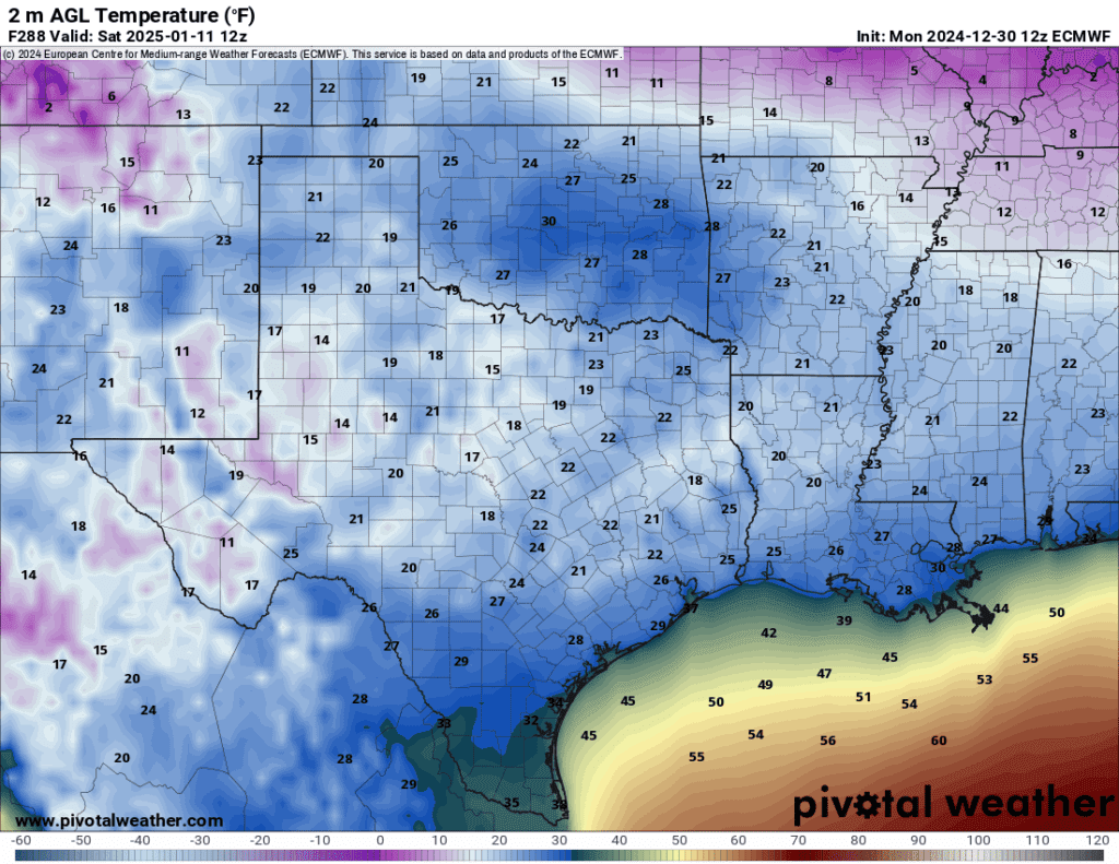
Out of the many cold days DFW could see over the first 2 weeks of January, this day could be one of the COLDEST days expected for North Texas. Temperatures will range from mid-teens to maybe low 20s in most areas. Again, just a rough forecast that is still far out, things are subject to still change.
CPC Outlooks
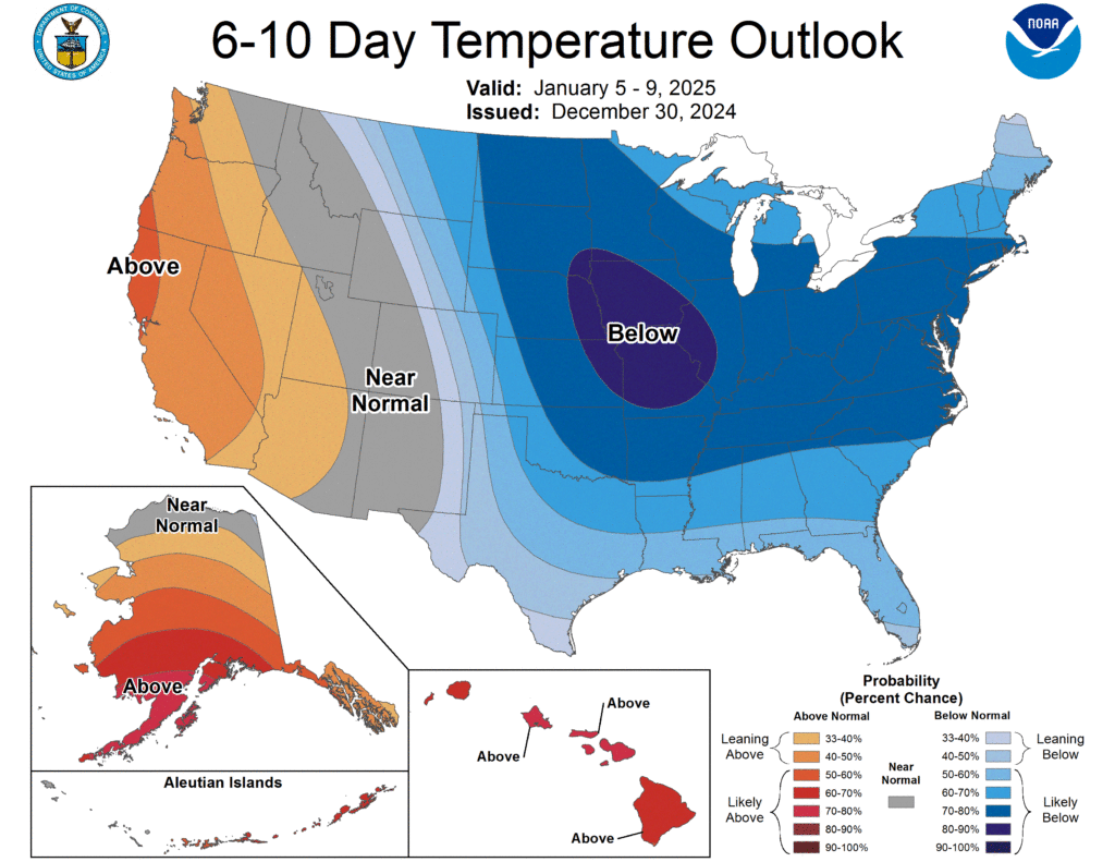
6-10 Day Outlook
The 6-10 day outlook shows continued cooler temperatures for much of Texas. Winter precipitation has entered the picture as well for the next week
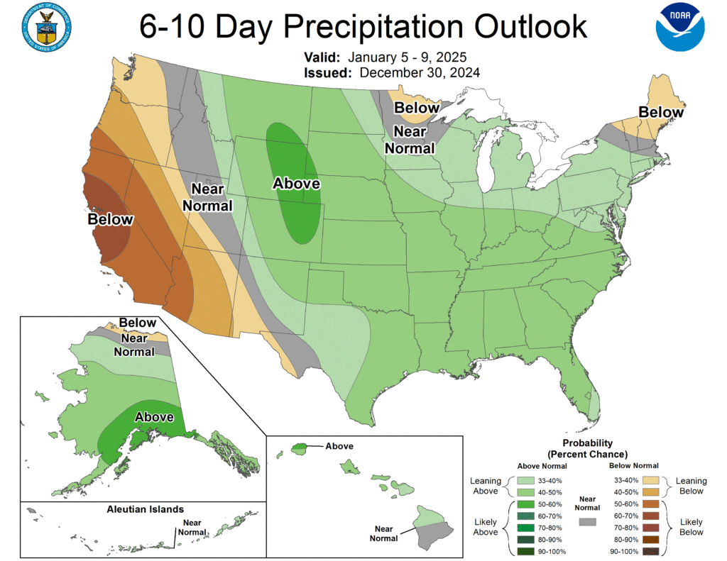
Heavy Snow Chances January 7-9th

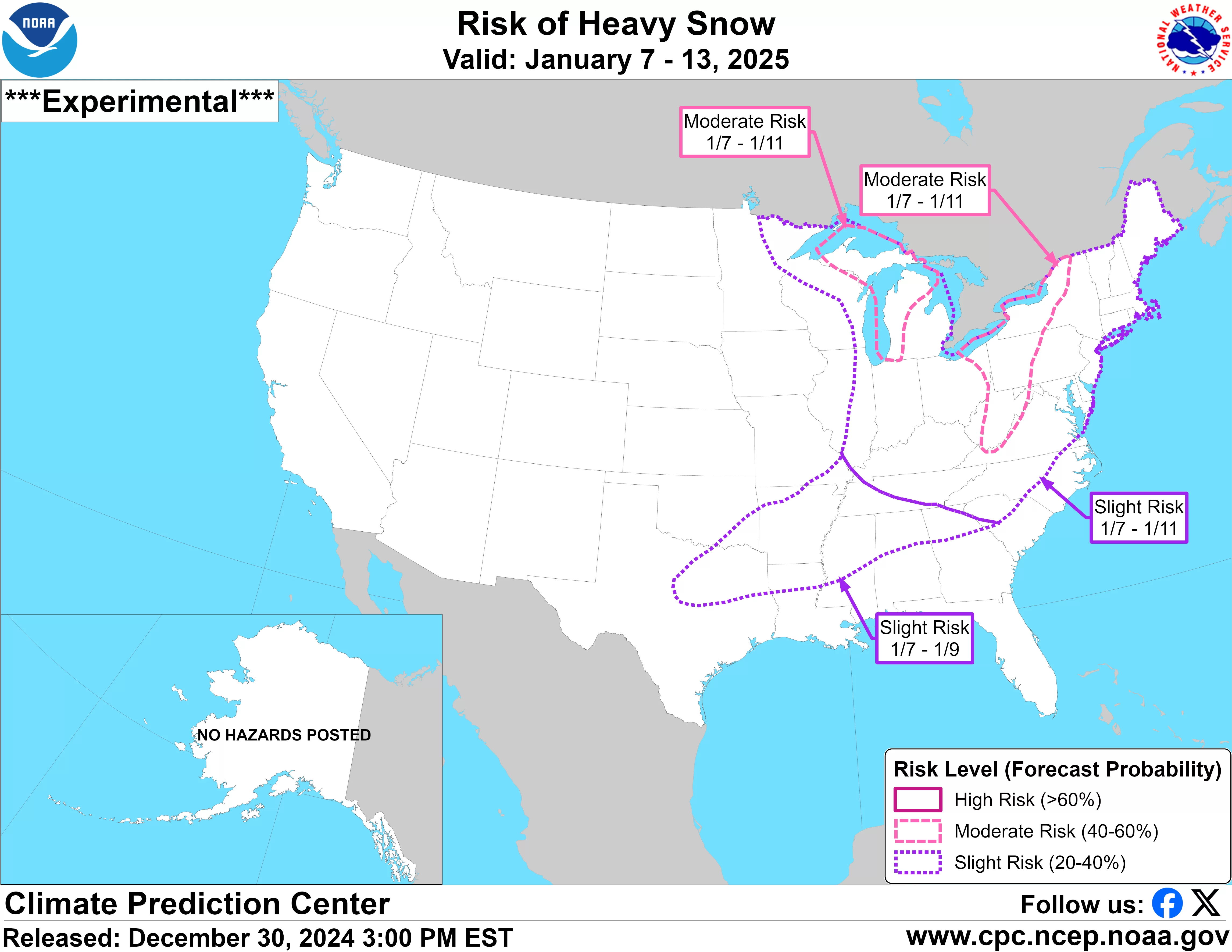
Here’s when things get interesting. Climate Prediction Center issued a slight risk for Heavy Snow for all of North Texas on January 7-9th. This means that CPC predicts a 20-40% chance of multiple inches of snow, potentially a winter storm situation for North Texas.
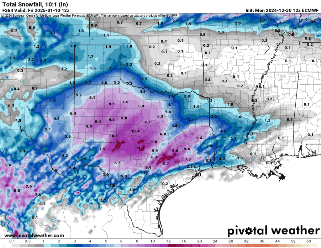
ECMWF Total Snowfall January 10th
GFS Total Snowfall January 10th
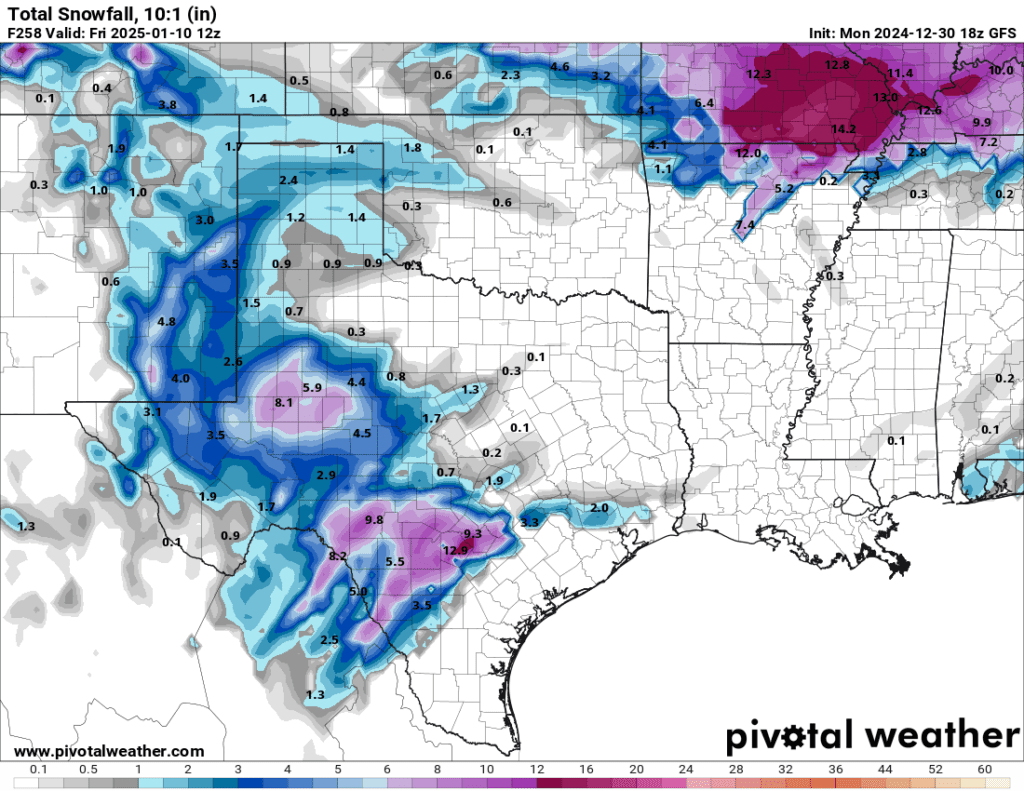
Above is a Total Snowfall weather model. These are from the EURO and GFS weather model. This is for the EXACT same day and there is such a vast difference in prediction. This is partly why we can’t trust one model by itself. Neither of these models will be correct. We will have to wait for more refined forecasts and agreement between them.
NOW, before everyone gets too worried, this is only an outlook. This doesn’t mean DFW will for sure get a winter storm. This also doesn’t mean DFW will for sure see any snow. This is still a far way out. However, the fact that the CPC issued an outlook and that models are starting to lean toward more wintery precipitation is something to take notice of and watch in the coming days. We cannot say anything is for sure yet, but we have to be prepared. So, which forecast is correct? Most likely neither because what actually may happen might be somewhere between these models. This is what happens when we deal with long-range weather forecasting. Once these models start having more agreement with each other is when we can have more certainty in these forecasts.
Will it Snow in North Texas?
Odds seem to be leaning more in favor of snow for North Texas during the January 7-11th period. Still, these are just long-range forecasts that are subject to change in location and timing. There is a lot of misinformation out there still and overhype. I want to try to deliver only the facts to you to keep you prepared, no distracting emotion!
Power Outage Issue
The next big question you may ask may be, “will there be widespread power outages again?” The short answer is, “maybe”. The long answer is complicated due to many factors. The bottom line is that the operational forecasting supervisor of the Electric Reliability Council of Texas (ERCOT) said if severe cold snaps occur in Texas—similar to the February 2021 storm—there is an 80% likelihood of blackouts affecting more than 27 million customers across Texas. This would not be good news if Texas indeed does face record cold. Although, according to the latest ERCOT monthly report, the grid has added 10,000 MW of new generation capacity since last winter to help sustain power across Texas. ERCOT has also conducted 2,892 new inspections of the grid system since the 2021 storm. Stay tuned for more information!
Track the Latest on TWC’s Facebook Page!
Become a TWC Member today for FREE!
Support Texas Weather Center
Join the TWC Membership through Patreon to show your support and keep TWC high quality and FREE!
Texas Weather Center Supporters
🥉Kathryn
🥇David Bass
🥉cslewis1234
🥉Robert Fasulo
🥈Carol
Join TWC’s Facebook Group to interact with a community, see the latest updates from TWC, and share your weather photos!
